October 12, 2016

Crooked Creek No. 3


We finally returned to this out of the way bridge near Riverside-Albert on a perfect October day.  This is the only covered bridge in the province that requires a hike along an old logging road to get to it.  It is now on an ATV/snowmobile trail in the Caledonia Gorge Protected Natural Area, but with an off-road jeep or truck you could drive very close to it in three seasons of the year.  I would not risk my vehicle on this track though; I've added some photographs of the trail after the bridge pictures below to give an idea of what it looks like, and people can judge for themselves.  Considering what a beautiful hike or mountain bike ride it is, there is little reason to try to drive to it, unless you are unable to walk for more than short distances due to physical restrictions. 


When you get to Riverside, the 114 takes a sharp left curve in the main village (coming from Riverview/Moncton direction), and a turning to the right here leads up to the Crooked Creek Lookout.  It is marked as Forestdale Rd. when you zoom in on the Google map at the top of this page, then turns into Crooked Creek Rd.  There is also a signpost at the curve pointing to the lookout, as shown in the photo above.

Either before or after you hike to the bridge, you must go up to the top to see the view.  

This is why:


In the picture above, you can see a bit of Crooked Creek down in the valley, which is where you will be heading.  The trail beyond follows the general course of the stream.

Getting to the bridge:

Take Forestdale/Crooked Creek Rd. up the hill, then just before you get to the lookout there is a fork in the road with a steep downward turn on the left that leads into the Caledonia Gorge.  Take this turn and slowly descend to the bottom.  It is in rough shape, so be ready to avoid deep pot holes.  Measuring from this turnoff, about 3 km down the road there are a couple of private fishing/hunting camps, and it is here that I leave my vehicle and hike the rest of the way in.  The road really turns into a rougher track at this point, with stones and deep ruts in places.  In the summer months, there can be lots of cars parked all along here, as this is a popular spot for swimming and weekend camping.  This makes for tricky maneuvering, but it can be done.  From these camps, it is an easy 40-45 minute hike to the bridge going at a moderate ambling pace.  This time measurement takes into consideration that we had an old dog with us on this trip, so did not go very fast; fit hikers would do it much  quicker.  I will stress that it is an easy hike, so don't be put off by the time and distance. 

There are a few paths leading off the main track that seem to be for ATVs, and I do not know where they go, but if you stick to the route that follows the course of the stream, you can't get lost.  A lot of the time, you cannot actually see the water, as the track is on higher ground and there is a lot of leaf coverage in the summer and fall, but you catch enough glimpses of it to know where it is.  It is quite challenging to follow along the stream itself as there is no footpath.  We tried that a couple of years ago on the first visit and gave up pretty quickly.

I hope this long explanation is helpful, and I've gone into detail because so many people have asked for proper directions to this bridge.  There aren't any reliable directions to be found anywhere else that I have searched, and the provincial D.O.T. website even says that the bridge is "inaccessible",  just to really confuse matters.

***

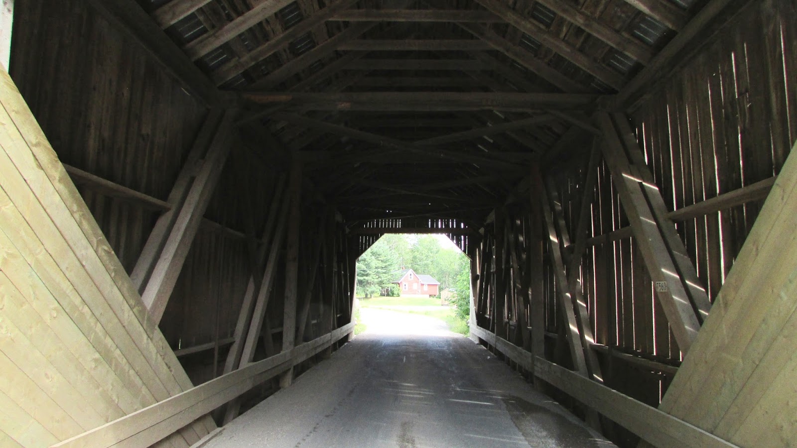
You will know that you are nearly at the covered bridge when you come to this narrow log bridge.  You need to cross over it, and then around the next curve in the road is the object of the journey.


Here, at last, is the Crooked Creek bridge.


The only sign on the bridge is this old Department of Public Works board with the clearance height marked.


***

The rest of the pictures are of the road to the bridge to give an idea of its condition in case anyone wants to attempt the drive.  It's in good shape where I left my vehicle in front of someone's fishing/hunting camp, then, as mentioned above, soon turns rocky and narrower.  There had been lots of rain in the days before this trip, so the puddles were deep too.


August 23, 2016

Milkish Inlet No.1 (Bayswater)


Today we went in search of the Milkish Inlet bridge, the last one in Kings County left for me to visit.  And what a gorgeous day out we had finding this one.  We took the Summerville-Millidgeville ferry across the Kennebecasis River to get to the Kingston Peninsula.  I prefer this one to the busier Gondola Point ferry further upstream, as it takes a bit longer and feels more like an adventure than a commute.   [Click here for up to date ferry crossing information.]  And then it is a very short drive to the bridge, 3 or 4 km.  

This is beautiful cottage country along here, perfect for slow afternoon drives, and there are also a few lighthouses to find on the way if you are an enthusiast.  I've added a picture of the rather unusual Sand Point lighthouse at the bottom of this page, for interest.  


A fairly busy bridge, there was steady traffic going across it while we were there.  It had a  number of boards missing or damaged on the south face that one would expect to have been repaired before this late date in construction/repair season. 

Inside, there were a couple of places where vertical steel reinforcement bars had been added to the structure, something I haven't seen before.


Underneath, you can see the concrete pier  in the middle supporting the two spans of the bridge.   The vast majority of New Brunswick's covered bridges are single span, though some of these have had steel beam piers added to save them from collapse, or to allow for the increased weight of modern  traffic.


***
Sand Point lighthouse  

This light, high on a skeleton tower, was built in 1869, one of the inland system of lighthouses along the Saint John River.  An enlargeable map with links to all the lighthouses in the province can be found here: Lighthouses of New Brunswick.


August 13, 2016

Trout Creek No. 5 (Moores Mills)


We finally revisited the two little bridges that span Trout Creek near Poley Mountain, southeast of Sussex.  Driving up through Fundy National Park, we thought we'd try something new - taking the Shepody Road west across country following the signs to Adair's Wilderness Lodge on Creek Rd.  The roads are not paved for about 20 km of this route until a little way north on Creek Rd, but they are in good condition overall (it's been a hot, dry summer so far this year, so caution to anyone reading this at a later date when seasonal changes can vastly alter these road surfaces).   

Trout Creek is a tributary of the Kennebecasis River that eventually empties into the Saint John River.  It is shallow enough to wade in and take profile photographs of the bridge here as it meanders along.  The bridge itself is one of the smaller ones in the province, extending less than 18m in length.  Of note, there is a measuring stick in the bank below against one of the abutments, which is the first time I have ever seen one in situ under a covered bridge, presumably put there for recording water levels in spring and other high water conditions.  


Trout Creek No.4 (Urney)


This is the other Trout Creek bridge visited today; another small one, about 20m in length.  It looks like there has been a recent concrete bank reinforcement added around one of the abutments, leaving the original stone work uncovered on the river face though, which is a nice touch.